How Flight Distance Is Established for CORSIA Reporting
· DSTechnoverse · CORSIA & Carbon Markets
Distance matters for the CERT tool, for data gap modelling and for cross-checking fuel figures. How great circle distance is computed, what allowance is added, and where diversions change the answer.
Flight distance is not itself a reported CORSIA quantity for operators using measured fuel. It matters in three other places, and each is important enough that the calculation should be done consistently and documented.
It drives the CERT tool estimate for small emitters, it underpins modelled fuel figures where data is missing, and it is the most useful cross-check available for validating a fuel figure that looks wrong.
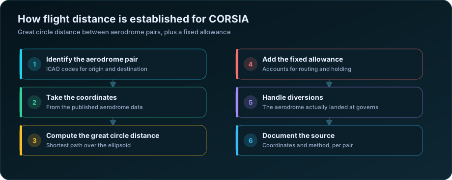
The method
| Step | Detail |
|---|---|
| 1. Identify the aerodrome pair | ICAO codes for the aerodromes actually used |
| 2. Obtain coordinates | Latitude and longitude from published aerodrome data |
| 3. Compute great circle distance | The shortest path over the earth ellipsoid |
| 4. Add the fixed allowance | Accounts for routing, holding and manoeuvring |
| 5. Record the result | With the coordinate source and calculation date |
Great circle distance is the shortest path between two points over the surface, which is shorter than any real flown track. Aircraft follow airways, avoid restricted airspace, take advantage of winds and occasionally hold. The fixed allowance added to the great circle figure is what accounts for this difference in a standardised way, rather than requiring operators to compute actual track distance.
The consequence for practice: the distance figure used for CORSIA purposes is a standardised construct, not a measurement of the track flown. It will not match the distance in the flight plan, and it is not meant to.
Coordinates, and where they go wrong
| Issue | Effect |
|---|---|
| Coordinates taken from a commercial database rather than published data | Small differences, but inconsistent over time |
| Aerodrome reference point versus a specific runway threshold | Negligible for distance, but be consistent |
| Aerodromes with more than one ICAO code historically | Mismatched lookups |
| Newly opened or renamed aerodromes | Missing from stale reference tables |
| Coordinate format inconsistency | Degrees-minutes-seconds against decimal degrees |
| Sign convention for west and south | A sign error moves an aerodrome to the wrong hemisphere |
The sign convention error is the one that produces spectacular results rather than subtle ones. An aerodrome placed in the wrong hemisphere produces a distance that is obviously wrong, which is fortunate — it is caught immediately. The subtler problems are stale reference data and inconsistent coordinate sources, which produce small persistent differences nobody notices.
Use one published source for aerodrome coordinates, record which, and refresh it on a defined cycle.
Distance as a validation tool
This is the use most operators overlook, and it is the cheapest data quality check available.
For a given aircraft type, fuel burn per kilometre falls within a reasonably predictable band. Plotting reported fuel against calculated distance for every sector produces a scatter in which errors stand out immediately.
| Pattern | Likely cause |
|---|---|
| A point far above the band | Unit error — litres recorded as kilograms |
| A point far below the band | Partial uplift recorded as total fuel |
| A cluster above the band for one station | Density convention wrong at that station |
| A cluster above for one aircraft type | Wrong type designator, or a genuine efficiency issue |
| Points at zero distance | Aerodrome pair missing or identical codes |
| Points on a separate line | A different aircraft type mislabelled |
Running this plot monthly catches the errors that a reconciliation between fuel and flight records cannot, because both records can be present and matched while the quantity itself is wrong. It complements the exception reporting described in when fuel records and flight records do not match.
Diversions and unusual sectors
| Situation | Distance basis |
|---|---|
| Normal sector | Great circle between the pair actually flown |
| Diversion to an alternate | The aerodrome actually landed at |
| Return to origin after departure | Origin to origin, with the operational reality documented |
| Technical stop | Two sectors, two distances |
| Positioning sector | Treated as any other sector |
| Training flight departing and returning | Document the treatment in the plan |
The return-to-origin case has no satisfying great circle answer, since origin and destination are the same point. Whatever treatment is adopted — a nominal distance, or exclusion from distance-based checks with the fuel still reported — should be stated in the monitoring plan rather than decided case by case.
For operators using measured fuel this is a minor issue, because distance is a cross-check rather than the basis of the emissions figure. For operators using the CERT tool it is more consequential, since distance drives the estimate directly — see the ICAO CERT tool.
Documenting it
| Element | To record |
|---|---|
| Coordinate source | Publication and version |
| Calculation method | Great circle over the ellipsoid, with the allowance applied |
| Refresh cycle for reference data | How often aerodrome data is updated |
| Treatment of diversions | Actual aerodrome governs |
| Treatment of return-to-origin sectors | Stated explicitly |
| Where distance is used | CERT, modelling, validation |
A short section in the monitoring plan covering these removes the question at verification. For the plan generally, see CORSIA emissions monitoring plan guide. Aerodrome reference data is published in state aeronautical information publications, and the calculation basis is described in the ICAO CORSIA implementation elements.
Frequently Asked Questions
How is flight distance calculated for CORSIA?
As the great circle distance between the origin and destination aerodromes, computed from their published coordinates, with a fixed allowance added to account for routing, holding and manoeuvring. It is a standardised construct rather than the actual track flown.
Does CORSIA distance match the flight plan distance?
No, and it is not meant to. Flight plan distance follows airways and wind routings, while the CORSIA figure is great circle distance plus a fixed allowance, applied consistently across all operators.
What distance applies when a flight diverts?
The distance to the aerodrome actually landed at, not the planned destination. Diversions should be captured automatically from the flight record rather than corrected by hand.
How can distance be used to check fuel data quality?
Plot reported fuel against calculated distance for every sector. Fuel burn per kilometre falls in a predictable band for each aircraft type, so unit errors, density problems at a single station and mislabelled aircraft types all stand out immediately as outliers.
What coordinate source should be used for aerodromes?
One published source, recorded in the monitoring plan, refreshed on a defined cycle. Mixing commercial databases with published aeronautical data introduces small inconsistencies that persist unnoticed across years.
How are return-to-origin sectors handled?
There is no meaningful great circle distance where origin and destination are identical, so the treatment — a nominal distance, or exclusion from distance-based checks with fuel still reported — must be stated in the monitoring plan rather than decided case by case.
Planning your CORSIA position? DSTechnoverse provides CORSIA carbon credit services for Indian operators and project developers — scope and readiness assessment, monitoring plans, data pipelines, verification support, unit sourcing and second-phase modelling. We are based in Indore, Madhya Pradesh and work across India.
Apply as a CORSIA buyer or seller
Talk to our carbon markets team about your position.