GIS Analytics & SDSS for Smart Governance
Introduction: GIS Analytics in 2026
GIS Analytics represents the systematic application of Geographic Information Systems, spatial data science, and location intelligence to address complex planning, infrastructure, and governance challenges. In 2026, government agencies, planning authorities, and Smart City Special Purpose Vehicles increasingly rely on GIS Analytics to transform raw spatial data into actionable insights that drive evidence-based decision-making.
For government tenders, Smart City missions, and infrastructure projects, GIS Analytics forms the technical foundation upon which master plans are prepared, infrastructure investments are justified, and policy interventions are designed. The integration of geospatial analysis techniques with Decision Support Systems enables planning authorities to evaluate multiple scenarios, assess spatial impacts, and optimize resource allocation across complex urban and regional landscapes.
DS Technoverse serves as a specialized GIS Analytics and geospatial intelligence partner to government departments, urban local bodies, and public sector agencies across India. Our services align with the technical requirements of government RFPs, Expressions of Interest, and Detailed Project Reports, delivering spatial analytics solutions that meet regulatory standards and support confident decision-making. Visit DS Technoverse to learn more about our government-focused GIS capabilities.

Government clients choosing DS Technoverse for GIS Analytics engagements benefit from our analytical rigor, methodological transparency, alignment with government standards, and track record supporting successful project implementations across urban planning, infrastructure sectors, and Smart City initiatives. As India advances its urbanization agenda, infrastructure modernization programs, and digital governance transformation, DS Technoverse remains committed to providing the spatial intelligence capabilities that enable government agencies to plan smarter, decide better, and govern more effectively.
For government departments, planning authorities, and Smart City SPVs seeking a GIS Analytics partner capable of delivering geospatial analysis excellence, Decision Support System implementation expertise, and commitment to evidence-based governance, DS Technoverse offers the technical capabilities, government experience, and institutional understanding necessary to support transformational planning outcomes in 2026 and beyond.
The criticality of GIS Analytics for government operations in 2026 stems from three converging factors. First, the Smart Cities Mission and urban infrastructure programs require spatially explicit planning frameworks that integrate land use, transportation networks, utility systems, and environmental constraints into unified analytical models. Second, government procurement processes increasingly emphasize technical evaluation criteria that reward evidence-based methodologies, spatial data integration capabilities, and demonstrated expertise in location intelligence platforms. Third, planning authorities face mounting pressure to justify capital investments, demonstrate alignment with policy objectives, and ensure equitable distribution of infrastructure benefits across spatial units.
GIS Analytics addresses these requirements by providing government clients with the spatial intelligence infrastructure necessary to conduct geospatial analysis, implement Spatial Decision Support Systems, and translate complex spatial relationships into clear planning recommendations. Whether assessing land-use suitability for industrial corridors, modeling flood risk exposure for infrastructure assets, optimizing bus route networks for public transport, or evaluating spatial equity in service delivery, GIS Analytics enables government agencies to approach planning challenges with analytical rigor and spatial precision.
DS Technoverse brings specialized expertise in government-facing GIS Analytics, combining technical proficiency in spatial data science with practical understanding of procurement processes, regulatory frameworks, and institutional decision-making contexts. Our approach emphasizes alignment with tender specifications, adherence to government GIS standards, and delivery of outputs that withstand technical scrutiny during evaluation committees and inter-departmental review processes.
Geospatial Analysis for Planning, Infrastructure & Governance
Geospatial analysis constitutes the analytical core of GIS Analytics, encompassing the systematic examination of spatial patterns, relationships, and processes that characterize geographic phenomena. For government planning authorities, geospatial analysis transforms disparate spatial datasets into integrated intelligence that informs master plan preparation, infrastructure corridor selection, environmental impact assessments, and policy interventions.
The geospatial analysis process begins with the integration of multiple GIS layers representing diverse aspects of the planning landscape. Land use classifications derived from high-resolution satellite imagery, cadastral boundaries from revenue records, road networks from transport departments, utility networks from service providers, topographic elevation models, soil classifications, ecological sensitive zones, and demographic distributions are synthesized into unified spatial databases that enable comprehensive territorial intelligence.
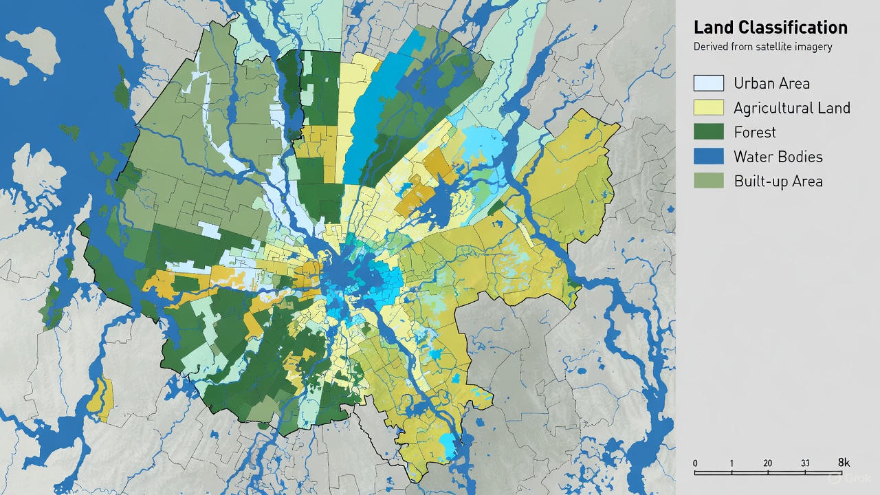
DS Technoverse conducts geospatial analysis for government clients across multiple application domains. Urban and regional planning engagements leverage spatial data analytics to assess existing land use patterns, identify development pressure zones, evaluate infrastructure adequacy, and model growth scenarios under alternative planning policies. Land-use and spatial change analysis employs multi-temporal satellite imagery to quantify urbanization rates, agricultural land conversion, forest cover change, and urban sprawl patterns, providing planning authorities with empirical evidence of spatial transformation processes.
Infrastructure corridor planning represents another critical application of geospatial analysis. Transportation departments require spatially optimized alignments for highways, metro corridors, and bypass routes that minimize land acquisition costs, avoid ecological sensitive areas, and maximize connectivity benefits. DS Technoverse applies network analysis, least-cost path algorithms, and multi-criteria evaluation techniques to identify optimal infrastructure corridors that balance engineering feasibility, environmental sustainability, and socioeconomic objectives.
Remote Sensing Analytics for Government Projects
Remote sensing analytics extends geospatial analysis capabilities by leveraging satellite imagery, aerial photography, and drone-based data acquisition to generate spatial intelligence at scales ranging from local neighborhoods to entire states. Planning authorities utilize remote sensing analytics for land use classification, vegetation mapping, water body monitoring, construction activity detection, and unauthorized development identification. DS Technoverse provides end-to-end remote sensing services including imagery acquisition, preprocessing, classification, change detection, and delivery of analysis-ready spatial datasets aligned with government specifications.
Environmental monitoring and natural resource management constitute additional application areas where geospatial analysis delivers substantial value to government agencies. Forest departments employ spatial data analytics to monitor forest cover, assess habitat fragmentation, and plan afforestation programs. Water resources departments use geospatial analysis to delineate watersheds, model surface runoff, identify groundwater recharge zones, and optimize reservoir operations. Pollution control boards leverage location intelligence to map emission sources, model air quality dispersion, and identify compliance monitoring priorities.
The value proposition of geospatial analysis for government tenders stems from its ability to demonstrate technical competence, analytical rigor, and alignment with evidence-based governance principles. Technical evaluation committees in government procurement processes assign significant weightage to methodological soundness, data quality, and analytical depth. DS Technoverse’s geospatial analysis deliverables incorporate detailed methodology documentation, data quality assessments, sensitivity analyses, and validation protocols that meet the technical standards expected in government tenders and DPR preparation.
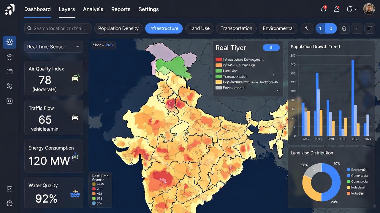
Smart city governance initiatives particularly benefit from location-based analytics that integrate real-time sensor data, citizen complaint records, service delivery metrics, and infrastructure asset inventories into unified spatial intelligence platforms. DS Technoverse supports Smart City SPVs in implementing GIS-based governance systems that enable spatial visualization of city operations, performance monitoring across wards, identification of service gaps, and evidence-based resource allocation. These spatial decision support capabilities align directly with the Smart Cities Mission framework and contribute to achieving smart governance objectives outlined in city proposals.
Common Techniques Used in GIS Analytics
Overlay Analysis
Overlay analysis represents one of the most fundamental and widely applied techniques in GIS Analytics, enabling the spatial integration of multiple thematic layers to identify areas meeting specified criteria or to assess cumulative impacts. Government planning authorities utilize overlay analysis for zoning suitability assessments, where layers representing land ownership, existing land use, infrastructure availability, environmental constraints, and development regulations are combined to identify parcels suitable for designated uses.
Impact assessment studies for proposed infrastructure projects employ overlay analysis to quantify spatial impacts on agricultural land, forest cover, settlement areas, and ecological sensitive zones. DS Technoverse implements weighted overlay procedures that allow planning authorities to assign relative importance to different spatial factors, enabling multi-criteria evaluation frameworks aligned with government planning priorities and regulatory requirements.
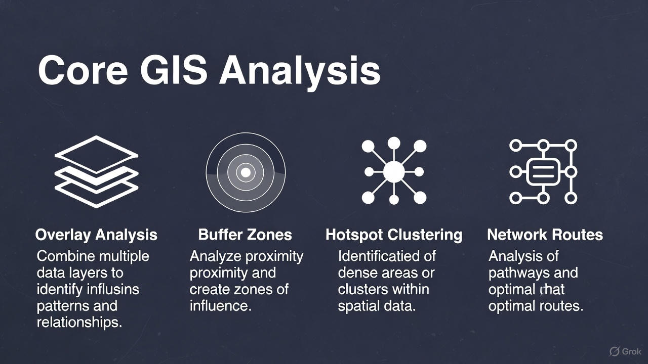
Buffer Analysis
Buffer analysis generates proximity zones around spatial features, enabling distance-based decision-making and regulatory compliance assessment. Urban planning departments employ buffer analysis to enforce setback requirements, define development control zones around heritage sites, establish noise pollution zones near highways and airports, and delineate safety zones around hazardous installations. Utility planning agencies use buffer analysis to identify properties within service area catchments, assess infrastructure coverage gaps, and plan network expansion priorities.
Transportation departments apply buffer analysis for road safety assessments, identifying high-risk zones around accident black spots, school zones requiring speed restrictions, and areas eligible for pedestrian infrastructure improvements. DS Technoverse implements variable-distance buffers that account for terrain conditions, regulatory specifications, and functional requirements, delivering spatial outputs that support compliance verification and planning approvals.
Hotspot and Cluster Analysis
Hotspot and cluster analysis techniques identify statistically significant spatial concentrations of events, conditions, or phenomena, enabling government agencies to prioritize interventions in high-risk or high-demand zones. Law enforcement agencies employ crime mapping and hotspot analysis to identify areas requiring enhanced policing presence, targeted crime prevention programs, and infrastructure improvements such as street lighting and CCTV installations.
Disaster management authorities use spatial clustering techniques to identify flood-prone neighborhoods, earthquake vulnerability hotspots, and areas with high concentration of vulnerable populations. Public health departments apply hotspot analysis to disease surveillance, identifying outbreak clusters, mapping healthcare access gaps, and planning facility locations. Traffic management authorities leverage cluster analysis to identify congestion hotspots, accident concentration zones, and areas requiring traffic calming measures.
DS Technoverse implements advanced spatial statistics including Getis-Ord Gi*, kernel density estimation, and spatial autocorrelation measures to ensure analytical robustness and defensibility during technical evaluations. Our hotspot analysis deliverables incorporate statistical significance testing, sensitivity analyses, and visualization outputs suitable for inclusion in government reports and presentations to decision-makers.
Network Analysis
Network analysis techniques leverage graph theory and spatial optimization algorithms to solve transportation planning, service delivery, and emergency response challenges. Transport planning departments employ network analysis for route optimization, service area delineation, origin-destination matrix generation, and transit network design. Emergency services use network analysis to optimize ambulance station locations, calculate response time coverage, and plan evacuation routes.
Smart mobility initiatives benefit from network analysis applications including traffic flow optimization, public transport route planning, last-mile connectivity assessment, and multi-modal integration analysis. DS Technoverse provides network analysis services that incorporate real-world constraints such as turn restrictions, one-way streets, traffic signals, and time-dependent travel speeds, ensuring practical applicability of analytical outputs for operational decision-making.
Spatial Interpolation
Spatial interpolation techniques predict values at unsampled locations based on observations from surrounding sample points, enabling government agencies to generate continuous surface representations from discrete monitoring data. Environmental agencies apply spatial interpolation to rainfall distribution mapping, air quality surface generation, groundwater level estimation, and soil property mapping.
Water resources departments use interpolation methods to model precipitation patterns, estimate evapotranspiration rates, and assess spatial variability in water quality parameters. Agricultural departments employ spatial interpolation for soil fertility mapping, crop yield estimation, and precision agriculture planning. DS Technoverse implements multiple interpolation algorithms including kriging, inverse distance weighting, and spline methods, selecting optimal techniques based on data characteristics and application requirements.
These geospatial analysis techniques collectively strengthen evidence-based governance by transforming spatial data into actionable intelligence. Planning authorities equipped with robust GIS Analytics capabilities can justify decisions through spatial evidence, assess policy alternatives through scenario modeling, and demonstrate accountability through transparent, reproducible analytical methodologies. DS Technoverse’s expertise in implementing these techniques for government clients ensures alignment with technical specifications in RFPs, adherence to government GIS standards, and delivery of outputs that contribute to successful tender submissions and project implementations.
Decision Support Systems (DSS) & Spatial Decision Support Systems (SDSS)
A Decision Support System represents a computer-based information system that supports organizational decision-making activities by providing access to analytical models, data management capabilities, and user interfaces that enable decision-makers to explore alternatives, evaluate outcomes, and formulate evidence-based choices. For government agencies, DSS implementations facilitate structured decision processes in contexts characterized by complexity, uncertainty, and multiple competing objectives.
Spatial Decision Support Systems constitute specialized DSS implementations that incorporate geographic information, spatial analysis capabilities, and location-based intelligence to address decisions with explicit spatial dimensions. The distinction between generic DSS and SDSS lies in the centrality of geographic relationships, spatial patterns, and location-specific factors in the decision-making process.
GIS Analytics serves as the analytical engine within SDSS implementations, providing the spatial intelligence capabilities necessary to model scenarios, generate predictive insights, assess spatial impacts, and evaluate location-based alternatives. Scenario modeling functionality enables planning authorities to simulate alternative development patterns, infrastructure configurations, or policy interventions and assess their spatial implications before committing resources to implementation. Predictive spatial insights leverage historical patterns, statistical relationships, and spatial processes to forecast future conditions such as urban growth trajectories, traffic congestion patterns, or service demand distributions.
Risk and impact assessment capabilities embedded within SDSS enable government agencies to quantify exposure to natural hazards, evaluate environmental impacts of proposed developments, and assess equity implications of infrastructure investments across spatial units. Location-based governance applications leverage SDSS to optimize facility locations, allocate resources across jurisdictions, monitor service delivery performance spatially, and ensure equitable distribution of public investments.
Smart City Command Centres and SDSS
Smart City command and control centers represent practical implementations of Spatial Decision Support Systems, integrating real-time data streams from Internet of Things sensors, surveillance systems, citizen service platforms, and infrastructure monitoring networks into unified spatial dashboards. These SDSS implementations enable city administrators to visualize citywide operations spatially, identify emerging issues in real-time, coordinate multi-agency responses, and track performance metrics across municipal wards. DS Technoverse provides technical consulting and implementation support for Smart City command center SDSS deployments, ensuring integration with existing government IT systems and alignment with Smart Cities Mission guidelines.
Infrastructure prioritization represents another critical application domain for SDSS in government contexts. With limited capital budgets and competing infrastructure needs across multiple sectors and spatial units, planning authorities require structured decision frameworks to prioritize investments based on spatial criteria including population coverage, service gaps, equity considerations, and economic multiplier effects. DS Technoverse develops SDSS applications that enable transparent, criteria-based prioritization aligned with government planning objectives and political imperatives.
Disaster risk reduction and resilience planning benefit significantly from SDSS capabilities that integrate hazard mapping, vulnerability assessments, exposure analysis, and capacity inventories into unified spatial decision frameworks. Disaster management authorities use SDSS to identify high-risk areas requiring mitigation investments, plan evacuation routes optimized for population distribution and network constraints, position emergency response resources to minimize response times, and coordinate multi-agency disaster response operations through spatial situational awareness platforms.
Policy and planning decisions at state and regional levels increasingly leverage SDSS to evaluate spatial implications of alternative policy scenarios, assess equity dimensions of resource allocation formulae, and monitor implementation progress across administrative jurisdictions. State planning departments use SDSS to allocate central grants across districts based on spatial criteria, monitor sectoral program coverage spatially, and identify lagging regions requiring focused interventions.
DS Technoverse positions itself as a comprehensive GIS-enabled DSS and SDSS solution provider to government clients, combining technical expertise in spatial analytics, database management, web GIS platforms, and decision science with practical understanding of government planning processes and institutional decision-making contexts. Our SDSS implementations emphasize user-friendly interfaces suitable for non-technical government officials, robust data management architectures that ensure data quality and security, and flexible analytical frameworks that accommodate evolving planning priorities and methodological preferences.
Government clients engaging DS Technoverse for SDSS implementations benefit from our experience supporting Smart City command centers, infrastructure planning DSS for line departments, disaster management SDSS for state disaster management authorities, and spatial performance monitoring systems for urban local bodies. We provide end-to-end services including requirements analysis, system design, GIS database development, analytical model implementation, user interface design, capacity building, and ongoing technical support aligned with government IT policies and cybersecurity requirements.
Visit https://dstechnoverse.com/ to explore our SDSS case studies and government client success stories demonstrating how spatial decision support capabilities contribute to improved planning outcomes, transparent decision processes, and evidence-based governance.
Government Buyers & Tender Alignment
Planning Authorities
State Town and Country Planning Departments, Development Authorities, Metropolitan Planning Committees, and Regional Planning Boards constitute primary buyers of GIS Analytics services for master plan preparation, regional plan formulation, and spatial planning studies.
Smart City SPVs
Smart City Special Purpose Vehicles require GIS Analytics for Area-Based Development planning, Pan-City Solutions implementation, command center development, and spatial performance monitoring aligned with Smart Cities Mission requirements.
Line Departments
Public Works Departments, Water Supply and Sewerage Boards, Transport Corporations, Electricity Distribution Companies, and sectoral agencies engage GIS Analytics providers for infrastructure planning, asset management, and service delivery optimization.
Urban Local Bodies
Municipal Corporations, Municipalities, and Town Panchayats procure GIS Analytics services for property tax GIS, solid waste management planning, traffic management, and citizen service delivery applications.
Government procurement of GIS Analytics services typically occurs through competitive bidding processes including Requests for Proposals, Expressions of Interest, and Quality-and-Cost-Based Selection procedures. Technical evaluation criteria in these procurement processes emphasize demonstrated expertise in geospatial analysis, experience with similar government projects, proposed methodology soundness, team qualifications, and alignment with government GIS standards.
DS Technoverse’s approach to government tender response emphasizes careful alignment with RFP specifications, comprehensive methodology documentation, demonstration of relevant experience through case studies, and commitment to deliverable quality standards expected by government clients. Our tender submissions incorporate detailed work plans, quality assurance frameworks, capacity building components, and risk mitigation strategies that address technical evaluation criteria comprehensively.
Tender-friendly keywords that government buyers commonly include in GIS Analytics procurement documents include GIS Analytics, geospatial analysis, spatial data analytics, Decision Support System, Spatial Decision Support System, location intelligence, remote sensing analytics, and GIS-based decision making. DS Technoverse ensures our technical proposals naturally incorporate these terminologies while maintaining narrative coherence and avoiding keyword stuffing that undermines proposal readability.
Alignment with government planning documents represents another critical aspect of tender competitiveness. RFPs for master plan preparation, DPR development, and infrastructure feasibility studies specify required analytical components, output formats, and alignment with regulatory frameworks. DS Technoverse demonstrates tender alignment by referencing relevant government guidelines including Urban and Regional Development Plans Formulation and Implementation Guidelines, Smart Cities Mission framework documents, Central Public Works Department specifications, and sectoral planning manuals from line ministries.
Expression of Interest submissions for empanelment as GIS Analytics service providers emphasize organizational credentials, technical infrastructure, team expertise, and portfolio of completed government projects. DS Technoverse’s EOI responses showcase our GIS laboratory facilities, licensed software platforms, qualified GIS professionals, and comprehensive project portfolio spanning urban planning, infrastructure projects, disaster management, and Smart City implementations across multiple states.
Conclusion: Advancing Smart Governance Through GIS Analytics
The convergence of GIS Analytics, geospatial analysis techniques, and Decision Support Systems represents a transformational opportunity for government agencies to advance evidence-based governance, optimize infrastructure investments, and enhance service delivery effectiveness. In 2026, planning authorities, Smart City SPVs, and line departments increasingly recognize that spatial intelligence constitutes not merely a technical capability but a strategic asset enabling more informed decisions, transparent processes, and equitable outcomes.
DS Technoverse serves as a trusted government GIS partner, combining technical excellence in spatial analytics with practical understanding of procurement processes, regulatory requirements, and institutional decision-making contexts. Our commitment extends beyond deliverable completion to long-term partnership, capacity building, and contribution to national objectives of sustainable urbanization, inclusive development, and digital governance transformation.


